Venediger altitude trail

High mountain trail in up to 8 stages from Prägraten a.Großvenediger to the Gschlösstal valley

Feel the fresh breeze at the foot of a glacier, feel free as a bird simply breathe freely. The Venediger Altitude Trail lets you forget any ballast of everyday life.

Starting from the car park Ströden in Prägraten am Großvenediger, it goes along the road to the Maurertal to the valley station of the material cable car. (Luggage transport possible!) The trail leads through larch and spruce forests along the Maurerbach stream. After the upper Ochsnerhüttet, you reach the Essener-Rostocker Hütte via a former lateral moraine of the Simonykees: a small detour to the Simonysee with a magnificent view of the glacier world is worthwhile!

Continue along the Schwerinerweg into the Maurertal Valley, and then quickly gain altitude in serpentines up to the Türmljoch (2,772 m).

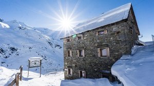
The descent leads evenly, well marked with stone markers, and in the lower section of the path becomes increasingly steeper, to the oldest hut in the Eastern Alps, the Johannishütte (built in 1857, expanded in 1999). Before starting this stage, the decision must be made whether to take the normal route via the "Schernesscharte" to the Neue Sajat Hütte, or the alternative via the "Zopetscharte" to the Eisseehütte.

The normal route over the Sajatscharte had to be abandoned years ago because of the danger of falling rocks. In the meantime there is a new connecting path (black mountain path!) which is signposted as the "Kreuzspitz-Höhenweg" and leads over the "Schernesscharte", which runs along the ridge below the Kreuzspitze. The Kreuzspitze (3,155m) can be reached from there in ½ hour. As a reward for the ascent, a magnificent view of the highest mountains of the Venediger Group awaits. The descent to the Neue Sajathütte then leads over a "rocky path" secured with steel ropes. (demanding!)

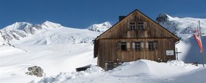
A less challenging and shorter transition leads from the Johannishütte on a direct path over the Zopatscharte (2,951 m) to the Eisseehütte. (red mountain path!) You leave the hut in an easterly direction, and climb up in some serpentines to a prominent "stone man". From there across the wide mountain meadows of the "Zopat" to the fork "Kreuzspitze" (2,750 m) and further east along the foot of the Zopetspitze to the Zopetscharte. The descent takes place the first 100 Hm in steep hairpin bends (rope-secured!), and then leads down to the valley floor of the "Kleinitzalm". After crossing the Timmelbach you will reach the Eisseehütte in a short time.
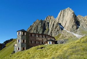
From there you hike, staying more or less at the same altitude, below the Großer Hexenkopf, the Hoher Eichham and around the Wunspitze, over the Eselsrücken to the Bonn-Matreier-Hütte.

Via the Kälberscharte (2.791m) and the Galtenscharte (2,871 m) the route continues to the Badener Hütte. This section is, depending on snow conditions, often only accessible in high summer. A short section is also secured with a rope, but can be easily climbed without a via ferrata set. Due to the danger of falling rocks, however, this section should only be climbed in dry conditions. The rest of the route leads through the picturesque and rustic Frosnitztal valley to the Badenerhütte.

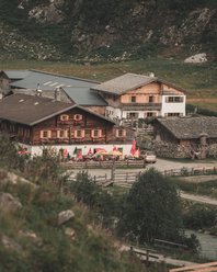
From the Badenerhütte you climb up to the Löbbentörl, one of the best places regarding panoramic view, and then down towards the Salzbodensee. Shortly before you turn left and follow the signs Gletscherweg, direction Neue Prager Hütte. The view to the left in the direction of Schlatenkees invites you to take a short break. For brisk hikers, a short detour to the glacier is also an option. On the descent, follow the signs to Venedigerhaus Innergschlöß. In many serpentines you reach the Venedigerhaus Innergschlöß after about 4.5 hours. From there on foot, by hut cab or panorama train to the MatreierTauernhaus.

Alternatively, you can continue on the path from the Badener Hütte to the Neue Prager Hütte and the St. Pöltner Hütte.

back
Next
Unique waterfalls
Unique waterfalls
in the Gschloesstal valley high above the Venedigerhauses Innergschlöß
Traditional huts
Traditional huts
with a long history of mountaineering
Majestic Peaks
Majestic Peaks
tower above the long distance hiking trail
Well developed paths
through lush green alpine meadows with a rich fauna and flora

Venediger altitude trail

starting point:
Car park Ströden / Prägraten a.G. 1.450m
destination point:
Matreier Tauernhaus 1.512m
highest point:
2900 m
total walking time
27 h
distance
55.5 km
🔋
altitude meters uphill
3915 hm
🞽
difficulty
average

The stages of the Venediger altitude Trail

The long-distance hiking trail can be walked in 3 - 6 stages. However, the structure can be individually and differently. We are happy to help you with your personal tour planning.

Venediger Altitude Trail Stage 1

starting point:
Car Park Ströden 1.450m
destination point:
Essener-Rostocker-Hütte 2.208m
highest point:
2208 m
total walking time
2:30 h
distance
5.3 km
🔋
altitude meters uphill
800 hm
🞽
difficulty
average

Venediger Altitude Trail Stage 2

starting point:
Essener-Rostocker-Hütte 2.208m
destination point:
Johannishütte 2.121m
highest point:
2772 m
total walking time
3 h
distance
7.6 km
🔋
altitude meters uphill
570 hm
🞽
difficulty
average

Venediger Altitude Trail Stage 3

starting point:
Johannishütte 2.121m
destination point:
Neue Sajathütte 2.600m
highest point:
3070 m
total walking time
4:30 h
distance
6.2 km
🔋
altitude meters uphill
960 hm
🞽
difficulty
difficult

Venediger Altitude Trail Stage 3 Alternative Zopetscharte

starting point:
Johannishütte 2.121m
destination point:
Eisseehütte 2.521m
highest point:
2958 m
total walking time
4 h
distance
5.4 km
🔋
altitude meters uphill
840 hm
🞽
difficulty
average

Venediger Altitude Trail Stage 4

starting point:
Neue Sajathütte 2.600m
destination point:
Bonn-Matreier Hütte 2.750m
highest point:
2750 m
total walking time
6:45 h
distance
12.05 km
🔋
altitude meters uphill
770 hm
🞽
difficulty
average
state: open

🞽
difficulty

Venediger Altitude Trail Stage 5

starting point:
Bonn-Matreier Hütte 2.750m
destination point:
Badener Hütte 2.608m
highest point:
2871 m
total walking time
5 h
distance
9.2 km
🔋
altitude meters uphill
550 hm
🞽
difficulty
average

Venediger Altitude Trail Stage 6

starting point:
Badener Hütte 2.608m
destination point:
Matreier Tauernhaus 1.512m
highest point:
2770 m
total walking time
5:30 h
distance
15.6 km
🔋
altitude meters uphill
320 hm
🞽
difficulty
average

Hut overnight stay at the Venediger altitude Trail

Whether comfortable in double or multi-bed rooms or simply in the camp - the huts along the Venediger altitude Trail offer the right accommodation for every hiker.

infrastructure.name
Alpengasthof Matreier Tauernhaus 1.512m
infrastructure.name
infrastructure.name
Bonn-Matreier-Hütte 2.750m
Wallhorn 8c
9974 Prägraten am Grossvenediger
infrastructure.name
open today
Eisseehütte 2.521m
Wallhorn 6
9974 Prägraten a.G.
infrastructure.name
open today
Essener-Rostocker Hütte 2.208m
Maurertal 1
9974 Prägraten am Grossvenediger
infrastructure.name
open today
Johannishütte 2.121m
Hinterbichl 19 b
9974 Prägraten a.G.
infrastructure.name
Neue Sajathütte 2.600m
infrastructure.name
Venedigerhaus Innergschlöss 1.691m

More information

Access and descent possibilities are regularly given.

Thehuts must absolutely be reserved, as only limited sleeping places are available!
There is no luggage transfer available on the long-distance trail.


Timetable Matreier Tauernhaus - Prägraten and back: www.vvt.at
Current weather situation in Osttirol: Osttirol weather
Current trail conditions and information on trail closures: Contact the respective hut or the tourist information office.

Maps and brochures are available at every tourist information office and can also be ordered.

You may also be interested in

Karlsbaderhütte
Checklist long distance hiking
Newsletter

Subscribe to our newsletter and receive the best tips every month for current offers, mountain tours, events and much more.