The Eagle Walk Osttirol

Go where the eagle flies

The eagle hovers proudly high in the sky, circling undisturbed and seemingly removed from everyday life. This is the feeling that guests in Osttirol will be able to experience when they set out on the Eagle Walk. With the Eagle Walk, an alpine mountain trail has been created that provides hikers with unique views. Like the bird of prey, one has a sublime view from above down into the valleys and of the most diverse mountain ranges - most of the stages run at a constant altitude between 2000 and 2500 meters.


For the tenth anniversary of the Eagle Walk, the routes have been completely revised. In Osttirol, nine stages leads from Ströden at the foot of the Großvenediger to the Stüdlhütte on the Großglockner for a total of around 100 kilometers.

If the most beautiful connection between two of the highest mountains in Austria is walked in its entirety, a sporty 8000 meters in altitude uphill and downhill have to be mastered. However, the Eagle Walk does not only focus on the impressive nature, but also on the alpine history that was written here. You can walk in the footsteps of the great Alpine pioneers, but of course with much more comfort. Many of the huts where you can now spend the night in comfort and enjoy regional specialties - at the Stüdlhütte even a multi-course dinner - were once simple refuges.

back
Next
Mountain Joy
Mountain Joy
...when you start the hike.
Mountain view
Mountain view
...when you catch sight of the mighty ice giants of the Hohe Tauern
Mountain contrast
Mountain contrast
...when it is still summer in the valley and already winter on the mountain
Mountain meeting
Mountain meeting
...when you meet mountain companions on the lonely long distance hiking trail
Mountain satisfaction
...when you return to the valley
youtube video

Those who want to follow the signs of the eagle need to be in good shape, sure-footed and sometimes free from vertigo. An average daily stage has ten kilometers and a hiking time of five hours. However, it is not necessary to walk the tour in one piece: It is possible to descend to the valley every day and shorten the route individually.

Stage 1: Ströden - Johannishütte

This is a trail where the journey is as interesting as the destination. Enjoy cascading waterfalls, roaring creeks, towering seracs and views of glistening glaciers.

Trailhead of Osttirol’s Eagle Walk Stage 1 is at Prägraten/Ströden, close to spectacular Umbal Waterfalls. Starting under a canopy of ancient larch trees, the trail begins its long and winding way up the mountain. As it breaks out of the woods, keep an eye out for marmots which can often be seen here on a sunny day. Walking past Göriach Ochsner Hut, the route continues to Essener-Rostocker Hut that provides the perfect rest stop for hikers. Follow Schwerin Trail beneath Kleiner Geiger on your way to Türml Col. Rock cairns as trail markers will show you the way to Johannis Hut, the oldest mountain refuge of the Eastern Alps. The hut dates back to 1857 and was completely refurbished in 1999. It's a little long and a little challenging getting to Johannis Hut. But the scenic rewards? Far from little-they're gigantic!

Eagle view

In the realm of “Three-Thousanders”, high altitude peaks averaging 3,000 metres in elevation, behold the unveiling of some of the most stunning views you’ll ever have. From Essener-Rostocker Hut gaze at ten towering peaks topped in ice that glistens in the sun. Johannis Hut affords vistas of majestic and impressive Großvenediger Mountain that will keep you mesmerized and captivated for long.

Eagle kick

2,844-metre Türml is a peak of Dorferkamm Ridge that is accessed within a 30 minute climb from Türml Col via a C graded Via Ferrata. The descent down the mountain’s south flank has some technical sections, assisted by a fixed anchoring system of cables, and views of Venediger Mountain that will inspire you.

Adlerweg trail. Stage 1: Ströden – Johannishütte

starting point:
Parkplatz Ströden
destination point:
Johannishütte
highest point:
2774 m
total walking time
7 h
distance
13 km
🔋
altitude meters uphill
1360 hm
🞽
difficulty
average

Directions

Starting point is the car park in Ströden, from there after the bridge proceed along the Maurerbach up to the Stoanalm snack station at 1450 metres. On the orographic left side of the river the trail heads to the valley station for the goods cable car. Continue on a steep trail up a valley section where larch trees are growing. After some two dozen steep hairpin bends up to Göriacher Ochsnerhütte (1948 metres), continue on the path, always close to the river, via tree-lined gentle slopes into the run-up to the glacier-covered Venediger mountains and to the bridge at the upper Ochsnerhütte at Maurerbach.


The powerful glacier river separates the Göriacher from the Maurer Alpe in the west. The route now proceeds in the final slope up to the Essener-Rostocker Hütte, in a moraine area of the secluded Simonykees area. After a well-deserved break continue hiking from Essener-Rostocker Hütte via Schweriner Weg. Negotiate the mountain flank via the hairpin bends and after about an hour of walking proceed along the south west slope of the Kleinen Geiger.


Proceed now via the grinding marks which were left during the Ice Age and via widely scattered scree fields to Türml and its bright red rocks, at whose base is the Türmljoch (2772 metres). To the east of here a path proceeds in loops along the path through snow hollows and the rubble surface, continuing down along the eastern slope of the Dorferkamm. Around ¼ hour later you turn, over a few rivulets, heading north east. The path then turns into terrain heading south across a mountain slope, down into the village of Bach, where you get to gaze in wonder at the lovely ground rocks. Finally the route proceeds past the memorial cross and via Zettalunitzbach on the final section to the traditional and spacious Johannishütte (2121 metres).

Stage 2: Johannishütte - Eisseehütte

The journey continues through the fascinating landscape of the high Alps from the Johannis Hut towards the Kreuzspitz High Trail, passing lush green meadows and later rocky terrain. Hikers have the option of a "detour" to the top of the Kreuzspitze Peak with its majestic views of the Großvenediger.

Fine hiking and breathtaking views are the reward for a long ascent. The Eagle Walk itself leads to the New Sajat Hut, known as the "castle in the mountains", but it is still quite a way from there to the official end point of this stage: the Eissee Hut.

Eagle view

There are few more spectacular experiences than hiking in the high Alps with their majestic glaciers. Take a "detour" via the Kreuzspitze Peak for some incredible views of the mighty Großvenediger mountain.

Eagle kick

The section between the Johannis Hut and the Sajat Hut is known as the "Schernesschaft" and comprises an exposed ridge requiring hikers to be 100% sure-footed and not afraid of heights. The crossing of the nearby Schernersschlucht Canyon is also a memorable experience.

Adlerweg trail. Stage 2: Johannishütte – Eisseehütte

starting point:
Johannishütte
destination point:
Eisseehütte
highest point:
3078 m
total walking time
7:30 h
distance
10 km
🔋
altitude meters uphill
1279 hm
🞽
difficulty
difficult

Continue through the fascinating mountains

The journey continues through the fascinating landscape of the high Alps from the Johannis Hut towards the Kreuzspitz High Trail, passing lush green meadows and later rocky terrain. Hikers have the option of a "detour" to the top of the Kreuzspitze Peak with its majestic views of the Großvenediger.

Fine hiking and breathtaking views are the reward for a long ascent. The Eagle Walk itself leads to the New Sajat Hut, known as the "castle in the mountains", but it is still quite a way from there to the official end point of this stage: the Eissee Hut.

Stage 3: Eisseehütte - Bonn-Matreier-Hütte

Summits as far as the eye can see… This is one of the best meadow-traversing, ridge-walking, view-granting hikes along the Venediger High Trail, bringing you close to prominent peaks such as Hoher Eicham, Großer and Kleiner Hexenkopf, Säulkopf and Rauhkopf. Sure, the terrain is rugged.

And yes, the trail has some steep ups and downs. But the tread is good, the vertical suffering short-lived and the scenery gorgeous.

Culminating on a ridge named Eselsrücken, literally, ‘the back of a donkey’, the hike gives a panoramic payoff of jagged peaks and emerald ridges that will leave you momentarily paralyzed. From the ridge, it’s a short walk down to Bonn-Matreier-Hütte Hut, a beautiful shingle-clad shelter that is your base for the night.

Eagle view

A rewarding one hour walk takes you from Eissee Hut to Eissee Lake, a pristine and clear Alpine lake flanked by rocky peaks. Wrapped in stunning scenery, Bonn-Matreier-Hut sits on a ridge of the southern flank of Eicham Range. One of the finest viewing outposts in the area, the hut will leave your head spinning as you try to identify a seemingly infinite array of peaks spread out before you: from close-ups of Lasörling Range all the way to the Dolomites and Schober Range. If the weather is clear, you’ll even have wonderful views of 2,864-metre Triglav, Slovenia’s tallest mountain.

Eagle kick

Peak baggers may want to nab the pinnacle of 3,371-metre Hoher Eicham Peak; the trail furiously works its way up to the top of Hoher Eicham from Bonn-Matreier-Hut. Noted for being one of the most striking Three-Thousanders of Venediger Range, with four ridges spreading in all directions, grade II-III climbing and rock scrambling awaits intrepid ones. The climb from the hut to the summit takes some 3.5 hours to complete.

Adlerweg trail. Stage 3: Eisseehütte – Bonn-Matreier-Hütte

starting point:
Eisseehütte
destination point:
Bonn-Matreier-Hütte
highest point:
2740 m
total walking time
3:30 h
distance
7 km
🔋
altitude meters uphill
544 hm
🞽
difficulty
average

Directions

From Eissee Hut, descend a few metres to get to the signpost of the Venediger High Trail, heading left to the eastern slopes of Timmeltal Valley. The traverse of Hexenkopf Peak’s southwest ridge follows an easy contour; then you will tackle the west ridge of Hoher Eicham Peak.

After a pleasant and almost level first section, get down to business. Climbing steeply, the trail furiously works its way up the west flank of Wunwand, assisted by stone steps and a fixed anchoring system of cables. The trail switchbacks up, traversing a tussock slope on its one-kilometre way to Wunwand’s southwest ridge. In this area, a trail branches off to Wallhornalm Alpine Pasture Hut in Timmeltal Valley; the High Trail, however, continues along a tussock slope south of Wunwand and rounds a minor spur of Wunspitze’s south ridge. Another 30-minute climb takes you to a niche; slightly above the trail divides, running left to Obere Wunalm and right to Untere Wunalm.

The route of the Venediger High Trail runs high above Virgental Valley. The way eases, then climbs again, this time to mount the ridge of Eselsrücken, which is the gateway to Großes Niltal Valley. A sharp little gully has to be descended in 15 switchbacks, below which you go down to a boulder field, crossing rivulets of Nilkees Glacier.

From here, the trail reveals Bonn-Matreier-Hut that is your destination. A well-maintained trail, beautifully crafted with stone steps, brings you to this stately shingle-clad shelter that is renowned for serving hearty specialties, which are perfect to gather new strength after the efforts of the day.  

Stage 4: Bonn-Matreier-Hütte - Badener Hütte

The rewards along this walk are great—stunning natural scenery, outstanding views, and clean air—but be prepared to work for every view you get. From Bonn-Matreier-Hütte Hut climb across talus and rock-laden terrain, slowing your pace as you clamber up to Säulkopf Peak. If you don’t want to summit it, head north to gain narrow Kälberscharte Crest and steep Galtenscharte Notch.

The trail is a bit rough and can be hard to follow in places; but you’ll get your first occasional glimpses of majestic Großglockner.

Clamber up and around large granite boulders at Galtenboden; and if you are up for the extra effort, summit Hohe Achsel Peak on a demanding trail that is assisted by a fixed anchoring system of cables. As you near Badener Hütte Hut, you’ll be greeted by a murmuring brook. The striking rock face above the hut resembles the notorious Eiger North Face and pays scenic dividends to tenacious trekkers.

Eagle view

If the weather is clear, you can savour one of the finest vantages for admiring spiralling Großvenediger Peak's sprawling sparkling glacier from the top of Säulkopfgipfel. And if you can ever move your eyes away from this mesmerizing mountain, a multitude of others demand your attention as well, from close-ups of Großglockner Range all the way to the Central Alps and the jagged peaks of the Dolomites.

Eagle kick

Galtenscharte Notch is an Alpine traverse and a demanding scramble section across rock-laden terrain, slowing your pace as you clamber up and around large granite boulders. The tread is poor and consists of loose rock in places; in return, you’ll get a superb panorama of nearly every peak of the Tauern National Park.

Adlerweg trail. Stage 4: Bonn-Matreier Hütte – Badener Hütte

starting point:
Bonn-Matreier-Hütte
destination point:
Badener Hütte
highest point:
2870 m
total walking time
5 h
distance
10 km
🔋
altitude meters uphill
651 hm
🞽
difficulty
difficult

Directions

A section above Bonn-Matreier Hütte (around 8-10 minutes’ walk), at the signposts the route branches off to the right. Proceed across a stony mountain trough and finally get to the rugged buttes of the Kälberscharte (2791 metres).

On both side of the wind gap a staircase and steel cables make the crossing into Kleine Niltal easier, which means you can even tackle the ascent to the higher Galtenscharte relatively problem-free. There is now a steep, challenging descent down to Mailfroßnitzbach, although you have to make up for this 600 metres altitude later on.

The upper section of the route is secured with steel cables, in the middle section a tough, steep snow field is there to tackle, often in the summer too. With a bit of luck and if the route is free of snow, you can proceed right along the trail. Further down the terrain becomes flatter, the descent ends at the bridge across the Mailfroßnitzbach.

About 40 metres below the bridge the trail continues. High above Froßnitztal you now cross the green slopes of the Hohe Achsel from south to north and pass a section of the route which is variety-packed in terms of the scenery it offers. Short sections are secured with steel cables, and you pass numerous little streams. On the so-called shoulder there is a tarn covered in grass and sealed up by a moraine. The Venediger altitude trail links up with the valley trail here. Continue to ‘Badener Hütte’, where you cross moraines which line up closely behind one another and finally the bridge on the Froßnitzbach. There are a few ridges and troughs providing protection for the snow grouse.

You eventually get to the lateral moraines of the Frosnitzkees, bear right here and continue hiking until you reach the destination for this hike, Badener Hütte (2608 metres) on the Großvenediger.

Stage 5: Badener Hütte - Matrei in Osttirol

Sprawling sparkling glaciers spreading out in all directions await the eager Eagle Walk hiker. Most of the way is along the Venediger High Trail, allowing you to sample one of the most famous long-distance hiking trails in the country. Heading north, a gentle grade takes you up to Löbbentörl, from where you’ll have wonderful views of surrounding Venediger Range and the Froßnitztal Valley below.

Passing Salzboden and the tiny tarn of the same name, the Glacier Trail aims eastward to Venedigerhaus Lodge at Inner Gschlöss. The Lodge serves hearty delicacies to hungry trekkers; once replete and replenished the trail continues to Outer Gschlöss and to the destination of the hike, Matreier Tauernhaus Lodge. What a workout!

This Eagle Walk segment is not for the weak of heart, nor the weak of knees; but the scenic rewards are many. Far from little-they're gigantic!

Eagle view

The loop walk along fascinating “Innergschlöss” Interpretive Glacier Trail takes some four hours to complete and gains 500 vertical metres; adequate equipment is required. Once arrived at Matreier Tauernhaus Lodge, you either rest and play for the day, or continue on to a pair of very pretty small lakes deeper in the surrounding wilderness. The historic rock chapel located between the Alpine pastures of Inner and Outer Gschlöss is a historic structure in Neo-Gothic style that is located directly on the Eagle Walk. Simply contemplate your good fortune while sitting here, surrounded by pure mountain beauty.

Eagle kick

What a workout! The walk from Badener Hut across Löbbentörl to Venedigerhaus Alpine Inn alone takes 4 to 4.5 hours to complete; with a knee-jarring descent from Löbbentörl to Innergschlöss. It’s a long journey, and steep in places; but manageable nonetheless. The rewards are great—outstanding views, clean air, and stunning natural beauty.

Adlerweg trail. Stage 5: Badener Hütte – Matreier Tauernhaus

starting point:
Badener Hütte
destination point:
Matreier Tauernhaus
highest point:
2760 m
total walking time
5:30 h
distance
14 km
🔋
altitude meters uphill
290 hm
🞽
difficulty
average

Directions

From Badener Hütte (2608 metres, you hike initially via the Venediger altitude trail and the Adlerweg trail (which is also the Badener Weg here) heading north for around an hour up to the Löbbentörl (2770 metres). A few rock-strewn gullies and little gorges are secured with ropes.

Across a short slope you ascend again to the Löbbentörl, where, protected by rocks, there is a cross and a commemorative plaque. From now on the route proceeds steeply uphill. The descent on the north side has short rope sections proceeding down to the rocky grassy ridge and settled snow down to the lateral moraine of the Schlatenkees. You continue to descend on this moraine. At the Untere Keesboden there is a crossing to Alten Prager Hütte (not open for business), where you can also take a detour and head to the fascinating glacier path ‘Innergschlöss’. The Venediger altitude trail passes Salzbodensee (2731 metres), in which the Hoher Zaun and Schwarze Wand are reflected.

To the north of the glacier white Gschlössbaches a path bears sharply east. In the well-managed Venedigerhaus which is close to the glacier (1689 metres) you can have a lovely rest. Along Gschlössbach continue heading out of the valley, between the Alpine pastures from the Inner- and Außergschlöss there is an old rock chapel where you can pause for thought. A more secular stop-off at Berghaus Außergschlöss (1700 metres) is recommended. The valley now spreads out.

From Gschlöss proceed down for around an hour, not even 200 metres to Matreier Tauernhaus (1512 metres), where, after the long, demanding descents of this stage will presumably be a bit easier on your knees. Enjoy a rest here, some delicious regional foods and enjoy a comfortable overnight stay.

Stage 6: Matrei in Osttirol - Sudetendeutsche Hütte

Giving you a good workout and an Achilles-aching ascent, the path climbs steeply and steadily from Matrei’s hamlet of Glanz, 1,445 metres above sea level, to Sudetendeutsche Hütte Hut, situated at the heart of Granatspitz Range at an elevation of 2,700 metres. Even for conditioned hikers this is a physically demanding trek with almost 1,300 metres of elevation gain.

But the payoff for that work includes historic mountain farms at the hamlet of Glanz and a multitude of blossoms at Edelweiss Meadow, 1,900 metres above sea level. When you tire of the rainbow of wildflowers on the ground, you can look up to find breathtaking vistas of Lasörling Mountain Range around every corner. Each switchback in the trail brings more of the mighty mountains into view.

Eagle view

A multitude of blossoms proliferate along this walk. But it's the edelweiss that dominate, transforming Edelweiss Meadow and environs into a true mountain majesty. In the area of Nussingkogel Peak you’ll might see rock crystals glistening in the sunlight.

Eagle kick

At one point you're directly under the towering spire of Falkenstein Mountain, hawks and golden eagles soar overhead. Look closely and you might see some Spiderman wannabes scaling its rocky walls—Falkenstein is a popular 7+ grade climbing terrain with some truly challenging areas for rock climbers at perpendicular faces rising 10 to 50 metres.

Adlerweg trail. Stage 6: Matrei in East Tirol – Sudetendeutsche Hütte

starting point:
Matrei in Osttirol (Glanz)
destination point:
Sudetendeutsche Hütte
highest point:
2650 m
total walking time
4 h
distance
8 km
🔋
altitude meters uphill
1198 hm
🞽
difficulty
average

Directions

It is preferable to start this stage at the car park in the hamlet of Glanz, which then saves you a two hour walk. From Matrei i.O. it is a 20 minute drive to get there (taxi service available on request). All those of you who also want to tackle the first section of this route on foot, can get from Matrei via Hinterburg to the car park on a road which is not much used.

From the car park in Glanz it takes 1 ½ to 2 hours to get to Äußere Steiner Alm and another 2 to 2 ½ hours to get to Sudetendeutschen Hütte. The trail proceeds for the most part through woodland which has ancient larch trees, pass Köfler-Almhütte (a private Alpine inn). In the area around the Ranzeralm you cross the road twice.

Just above Lackner Almhütte a cart track begins which crosses a spring, before heading from east to west through pastures of Edelweiß. Anyone who does not want to hike through the woodland can also head from the car park in Glanz along the forest road at the start of the Edelweiß pastures. After a rocky ledge the path, which has handrails, descends into a light larch forest.

Cross Steinerbach and get to the Alpine lodges in Äußere Steiner Alm (1914 metres), from Äußere Steiner Alm proceed in the flat floor of the Trogtal north-east, heading for the head of the valley. Little larch groves and mighty green schist boulders characterise this romantic route section. At the end of the valley head a goods cable car proceeds to Sudetendeutschen Hütte, in days past iron ore mining sites were located here, which is why this nook in the valley is described as the ‘Schmelzhütte’ (smelting lodge). The path to Sudetendeutschen Hütte proceeds uphill initially close to the Steinerbach, winding in hairpin bends up across sloping meadows, where you have the Nussingkogel to the left and the Bretterwandspitze to the right.

Finally the terrain becomes somewhat flatter with its summits shaped by glaciers and in the nearby area you will find the spacious Sudetendeutschen Hütte (2650 metres), set in the midst of the Granatspitz group.

Stage 7: Sudetendeutsche Hütte - Kalser Tauernhaus

This “Glockner Loop” segment of the Eagle Walk offers the best of Granatspitz Mountains as it skirts glaciers, summits a significant notch in the Hohe Tauern Range, drops down tussock slopes and delivers lake views, all while under the watchful guise of majestic snow and ice-crowned Großglockner Peak. From Sudetendeutsche Hut, the trail skirts Gradötz Glacier and ascends 2,848-metre Gradötz Notch, before dropping down into Dorfertal Valley to Kalser Tauernhaus Lodge. Once there, you either rest and play for the day, or, if you are up for the extra effort, take the one-hour detour for Dorfersee Lake, an aquatic gem wrapped in gorgeous scenery.

Eagle view

Großer Muntanitz is the highest peak of Granatspitz Range. Peak baggers may want to nab its pinnacle, but less adventurous souls will be perfectly content staying on the trail and watching it as it hovers at 3,232 metres. The way-marked access from Sudetendeutsche Hut is quite easy to negotiate in dry weather. If the weather is clear, you’ll have wonderful views of Großglockner to the east and Venediger Range to the west.

Eagle kick

Although the Eagle Walk runs below Gradötz Glacier, it can be treacherous in snow or adverse weather conditions and intimidating to an unseasoned hiker. A section of the trail crosses the steep hillside of Gradötz Notch that can retain snow until late in the season; hikers without adequate gear and experience are better off waiting until the snow has melted down before tackling Gradötz Notch; so before heading out, be sure to check with innkeepers or local tourist information offices to make sure this route is accessible.

Adlerweg trail. Stage 7: Sudetendeutsche Hütte – Kalser Tauernhaus

starting point:
Sudetendeutsche Hütte
destination point:
Kalser Tauernhaus
highest point:
2820 m
total walking time
4 h
distance
8 km
🔋
altitude meters uphill
209 hm
🞽
difficulty
average

Directions

From Sudetendeutschen Hütte hike past the memorial cross and a little mountain lake which is close to the lodge via a grassy ridge and mossy trough up to the outlet area of the Gradötzkees, where a lake has built up and impressive moraines characterise the landscape.

You finally get to Gradötzsattel (2826 metres), then head down to the Bloipalfen (2684 metres). Continue downhill afterwards via a section of pastureland and gorge-like rock formations. At some 2500 metres altitude the route branches off into Silesiaweg. It is a few minutes‘ walk on the rocky Muntanitzschneid, which provides wonderful views, staying on the Adlerweg trail, bearing right and finally reaching the Muntanitzbach, which is not so easy when there is considerable water flow to tackle – in particular the base. A section above the Ochsenalm area you walk around the ridge of the Muntanitzschneid. The route is very well developed here, in the lower section you walk on a small sharp bend and there is a rocky section.

Continue down across the pasture slopes and head in a northerly direction through a small Swiss stone pine woodland. You eventually come to an information board at the bridge on the Stotzbach which the Loamesbach flows into.

At the route signpost which is a bit further down opt for route 514 A, to Kalser Tauernhaus. Hike now on numerous narrow hairpin bends on the Wilhelm-Ernst trail between alders, ash trees and larch trees, zigzagging into the valley, past the National Park viewing turret, where a waterfall at the Stotzbach swirls down below to the depths via a trough shoulder created by glaciers from the Ice Age.

Finally head to the Dorferbach, to the destination for this stage, the cosy Kalser Tauernhaus (1755 metres). Located in the lower section of the Dorfertal, just a short section beneath the point where the Stotzbach meets the Dorferbach.

Stage 8: Kalser Tauernhaus - Stüdlhütte

This Eagle Walk segment has you hiking under the watchful guise of majestic Großglockner Peak and under the jagged, towering spires of Zollspitze, Säulspitze, Bretterspitze, Kristallspitze, and Kreuzwandspitze… Here, the forces of nature have conspired to create an improbably gorgeous landscape.

From Kalser Tauernhaus Lodge, a scenic trail ambles peacefully through rolling Alpine meadows blanketing idyllic Dorfertal Valley that is dotted by Schönebenalm, Bergeralm, Moaebenalm and Moaalm Alpine Pasture Huts. This awesome setting is made all the more spectacular by contrast with the dramatic mountainous terrain that stretches off in every direction near and far.

Quaint mountain huts along the trail provide the perfect rest stops for hikers. The route is gradually gaining elevation into Teischnitz Valley and the last section follows Herrensteig Trail past Figerhorn, Freiwandspitze and Fanotkogel to Stüdl Hut, sitting in a rugged bowl under the reign of majestic Großglockner Mountain.

Eagle’s view

On the mountain trails between Matrei and Kals, you will often come across rocks and mountains, which have the word "Brett" (board) in their name, like Bretterwandspitze. Like on this stage with Bretterspitze (board tip) and Bretterwand (board wall). This is no coincidence, because all these rock faces have one thing in common: The steep mica schist is reminiscent of smooth boards.

Eagle’s kick

A stretch on this stage runs above the wild and romantic Dabaklamm with its roaring waters. An impressive spectacle of the forces of nature, but surefootedness is a prerequisite for some very steep and sloping spots; especially in wet conditions, caution is required.

Adlerweg trail. Stage 8: Kalser Tauernhaus – Stüdlhütte

starting point:
Kalser Tauernhaus
destination point:
Stüdlhütte
highest point:
2800 m
total walking time
6:30 h
distance
14 km
🔋
altitude meters uphill
1382 hm
🞽
difficulty
average

Directions

From Kalser Tauernhaus the Adlerweg trail continues to the Moaalm, keeping south, through the lovely Dorfertal on a wide Alpine trail which descends slightly. Pass the Kalseralmen on the Rumesoi- and Schönebene. Just after the Bergeralm snack station, at Moaebene route no.

40 bears left via a path which requires surefootedness (‘die Stiege’), up to the Moaalm (1793 metres), just above Kals. Continue down across Moaalmstraße up to the bridge on the Teischnitzbach, where after about 70 metres at a gap in the fence a route signpost shows the way to Teischnitztal. This section is still very original and inspires with its lovely scenery. From there an Alpine trail heads up on the right side of the valley, where larch trees are growing.

There is also a shortened path which crosses the Alpine trail several times. It passes Maurigen Trog (2101 metres), a narrow, 800 metre rocky gorge (2075 metres). At the entrance to the high valley trough of the Teischnitz Ebene (bridge) a signpost shows that the route branches off here heading for Stüdlhütte bearing right into the steep mountain slopes. You soon are looking down to the rushing Teischnitzbach and see the ice towers of the Teischnitzkee flash. There are still a few steep pasture slopes, strips and gullies to tackle, before you finally approach the Stüdlhütte (2802 metres) via rubble and stone boulders. To the south of you you are at the foot of the Großglockner, the corresponding mountain and glacier panorama is superb.

Stage 9: Stüdlhütte - Lucknerhaus

Having spent the night at Stüdlhütte Hut – the closest you will get to majestic Großglockner Peak along the Eagle Walk – the route heads southward through improbably gorgeous landscape. Gaining Pfortscharte Notch along Johann-Stüdl-Trail, stop to take in newly emerging views of Salm Hut and wave a hello to the neighbouring Austrian Province of Carinthia. Follow Luckner Trail to stately Glorer Hut at Berger Törl, from where a scenic trail ambles down through rolling Alpine meadows blanketing the valley of Bergerbach Brook. Eventually you will reach the end of the Eagle Walk at Lucknerhaus Lodge. From here, scenic Kals Glocknerstraße Road snakes down to Kals. But, getting to the destination is a cause for celebration, and the sunny lodge is a logical post for calling it a day and savouring the last spectacular views of his majesty, Großglockner Peak.

Eagle view

In this area, where the forces of nature have conspired to create an improbably gorgeous landscape, you can try to reveal some of nature’s secrets along delightful interpretive trails, the “Geo Trail” at Luckner Trail and the “Glocknerspur – ThinkMountains” Interpretive Trail that has its trailhead at Lucknerhaus Lodge. On this last segment, look back and note majestic Großglockner rising as an elegant pyramid.

Eagle kick

Using plenty of fixed cable as support, the way across 2,800-metre Pfortscharte negotiates a rocky terrain of narrow ledges, shelves, little gullies, and scrambling pitches. In many places there’s considerable exposure, but invariably in such places you will find adequate cable support. There is also the danger of getting struck by lightning; it is not recommended to take this hike in rain and thunderstorm. Always check the latest weather forecast!

Adlerweg trail. Stage 9: Stüdlhütte – Lucknerhaus

starting point:
Stüdlhütte
destination point:
Lucknerhaus
highest point:
2820 m
total walking time
5:30 h
distance
11 km
🔋
altitude meters uphill
376 hm
🞽
difficulty
difficult

Directions

From Stüdlhütte on the Fanotscharte (2802 metres) climb in a northerly direction for five minutes, then bear east at the route signposts for Pfortscharte, Salmhütte, Glorer Hütte, heading south, south-east via route AV 713. This proceeds directly beneath the moraine fields of the Ködnitzkees and way above the so-called ‘Viehböden’ meet the Johann-Stüdl trail (AV 702 B). This initially well-developed trail now heads up through pasture slopes, which are then rope-secured up to the top.

Now into the rubble-strewn corrie, continuing up through the corrie. At the fork in the path in the corrie do not bear right at the rocks, but continue heading for Salmhütte up through the corrie. The path in this section proceeds in short serpentines through rubble and scree, but the subsurface is good. The route proceeds steeply up to the Pfortscharte.

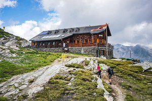
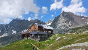
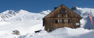
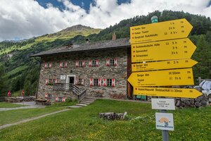
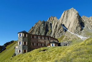
On the other side there is short section in similar terrain heading down, at the fork in the path keep to the signposts for „Glorer Hütte“. From here proceed on the Luckner Weg heading south, on lush, wavy mountain meadows past Obere Glatzsee and after a while you will get to Glorer Hütte at Berger Törl (2651 metres).

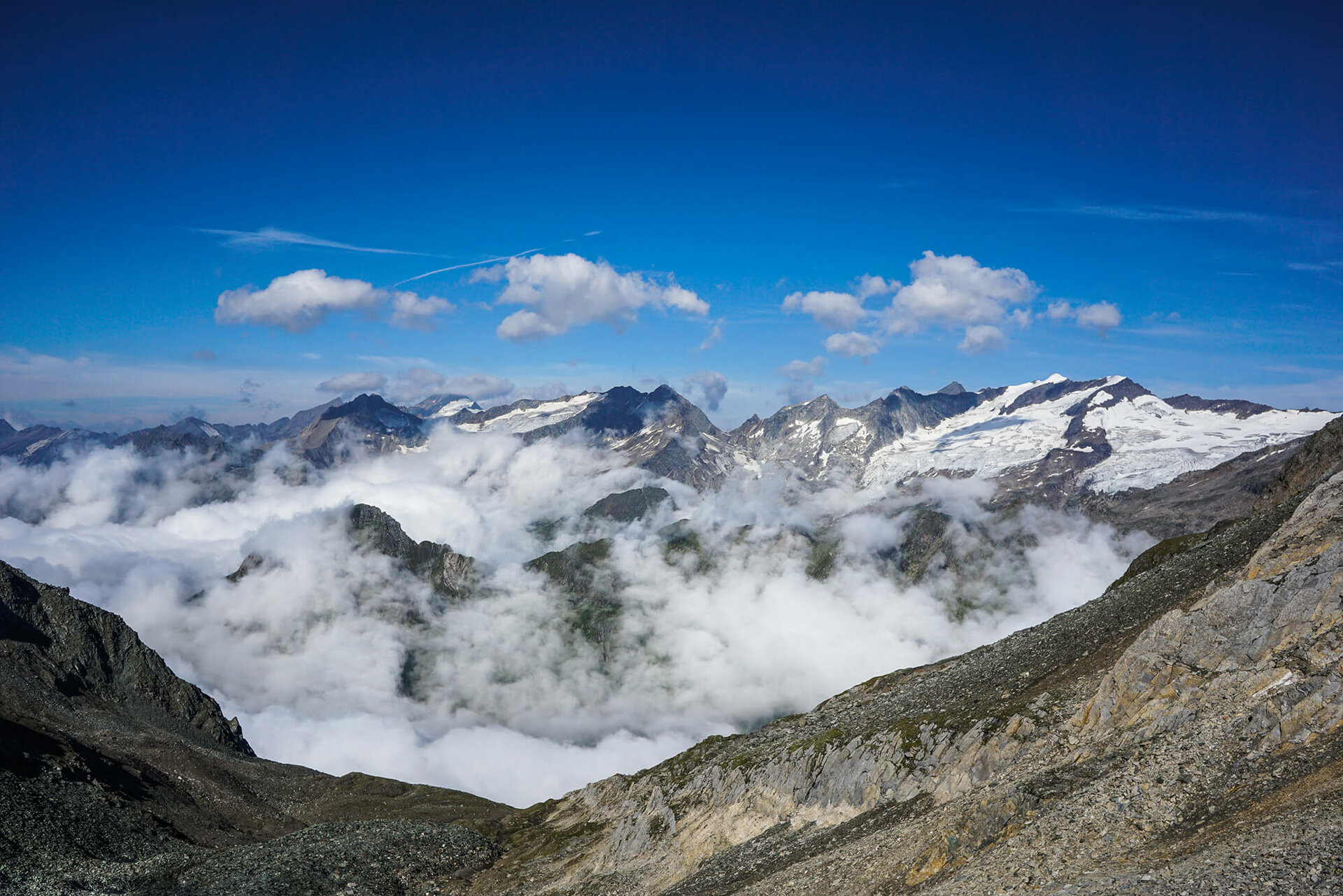
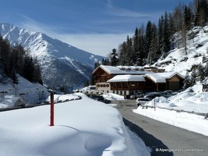
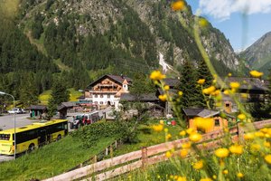
In the wide mountain valley, which stands out with its pasture slopes, there are terminal moraines, evidence of earlier glacier activity, which reach the trough and the Glatzbach. After Glorer Hütte the route proceeds parallel to the goods cable car on part of the earthy path and via few smaller streams into the valley down between mountain pastures, where to preserve the natural surroundings you have to keep to the path. The path then finally meets a wide trail which proceeds to the Lucknerhaus, the destination for this stage and the end of the Adlerweg trail in East Tirol! Or a lovely starting point, if you tackle the route from this way.

Hut overnight stay on the Eagle walk

Whether comfortable in double or multi-bed rooms or simply in the camp - the huts along the Eagle walk offers the right accommodation for every hiker.

infrastructure.name
open today
Alpengasthof Lucknerhaus 1.920m
Glor-Berg 16
9981 Kals am Großglockner
infrastructure.name
Alpengasthof Matreier Tauernhaus 1.512m
infrastructure.name
infrastructure.name
Bonn-Matreier-Hütte 2.750m
Wallhorn 8c
9974 Prägraten am Grossvenediger
infrastructure.name
open today
Eisseehütte 2.521m
Wallhorn 6
9974 Prägraten a.G.
infrastructure.name
open today
Essener-Rostocker Hütte 2.208m
Maurertal 1
9974 Prägraten am Grossvenediger
infrastructure.name
open today
Johannishütte 2.121m
Hinterbichl 19 b
9974 Prägraten a.G.
infrastructure.name
Kalser Tauernhaus 1.755m
Lana 9
9981 Kals am Großglockner
infrastructure.name
Neue Sajathütte 2.600m
More information

Access and descent possibilities are regularly given.

It is essential to reserve the huts, as there are only limited sleeping places available!
There is no luggage transfer available on the long-distance trail.


Timetable Matreier Tauernhaus - Matrei i. O. & Kals a. G. Lucknerhaus - Matrei i. O.:www.vvt.at
Current weather situation in Osttirol: Osttirol weather
Current trail conditions and information on trail closures: Contact the respective hut host or the tourist information office.

Maps and brochures are available at every tourist information office and can also be ordered.

You may also be interested in

Adlerweg Osttirol Etappe 1
Eagle walk Tyrol

In the high alpine mountain world, close under the sky, the Eagle walk leads from east to west throughout the Tyrol.

Adlerweg Osttirol Etappe 1
Austrian Alpine Club
Newsletter

Subscribe to our newsletter and receive the best tips every month for current offers, mountain tours, events and much more.